

 Jems
Development of agriculture 4.0 tools for sustainable soil management (Dig4Soil)
Priority Axis 1: Cooperating for smarter programme area
Operation start date: 15.07.2026
Operation completion date: 14.07.2028
Budget: EUR 528.335,27
Number of partners: 2
Operation purpose and expected achievements:
To develop innovative digital soil management services for subjects in agriculture sector offered by research centers from the program area through the transfer of knowledge and integration of information technologies in the field of agroecology and environmental protection.
The main outputs of the project are:
- Digital Platform for Sustainable Soil Management;
- Introduction of Precision Nutrient Management and Soil Analysis Models in the Programme Area;
- Partner organisations cooperating across borders on tools for sustainable soil management.
Beneficiaries:
Biotech (HR) as a lead partner will ensure professional management of the Operation which includes submission of all reports, transparent financial management and management of all activities, providing information about entire Operation as well as the progress of entire Operation. The role also includes providing all necessary human resources for successful project management and implementation of activities to achieve specific and overall objectives of operation and establish cross-border cooperation with partner to strengthen regions. Organisation will provide externa expert for project reporting and public procurement to ensure timely and smooth implementation of the project, while the center’s employees will work on the implementation of activities and the transfer of knowledge. Considering the overall objectives of the Operation Biotech is responsible for reaching this goal and implementation of new digital tools and joint solutions.

Biosense (RS) as a partner launched the digital platform AgroSense in 2017 and it has seven years of experience in developing farm management information systems, with various functionalities. Some of them are digital field records, satellite vegetation indices at the field level, weather forecast for the closest location, integration of the data from automatic weather stations, storing soil analysis data, statistical algorithm for management zones delineation from satellite images for targeted soil sampling with an optimal number of sampling points, an algorithm for soil organic matter assessment from satellite data, a basic calculator for fertilization management recommendations etc. BioSense will perform knowledge transfer on design, development and bottlenecks in the creation of innovative application for the agricultural producers in Croatia.


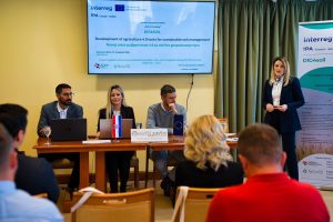
The kick-off meeting of the cross-border project Dig4Soil – Development of Agriculture 4.0 Tools for Sustainable Soil Management was held … Read More